Showing posts with label rock art. Show all posts

Saturday, August 19, 2023

Hawaii, Owyhee...uh, Böglands (Part Four)

As near as I’ve been able to calculate, the red arrow points to our base of operations on the Owyhee River. This location is at the bottom end of about 48 miles of class II and III rapids - that is, if you happen to be there in the middle of May. If you’re there at the end of August and maybe during a season of drought, traveling by raft is rumored to be problematic.

Sitting in the shade, fishing and drinking beer is nice, but you can’t do it all day. Well, actually, you can do it all day, but we were also cognizant of other points of interest in the canyon.


One such site was archeological in nature, but the people who know of such sites tend to be protective of them - and for good reason.


(LEFT: pictogram peppered with bullet scars. RIGHT: Same image modified with Jon Harmon’s DStretch to better delineate the original art.)

For instance, this antler man that appears near Maupin, Oregon appears to be the victim of fairly intensive target practice.


(TOP: Various carved images - a medallion, a humanoid figure and a sunburst all defaced with spray paint. BOTTOM: The same image modified with Jon Harmon’s DStretch reveals a layer of spray paint that betrays a more modern, angsty origin.)

And these carved petroglyphs (also near Maupin) appear to have been covered in various layers of spray paint.


(Detail of the humanoid carving that appears beneath the ‘N’ in Tanya)
 

(TOP: Original image of pictograms in Picture Gorge. Note graffiti scratched over the top. BOTTOM: The same image modified with Jon Harmon’s DStretch to better reveal the extent of the original pictograms.)

And these Picture Gorge pictograms have likely been damaged by someone wielding a sharp rock as a scraping implement.


Because of the protective reticence to share indigenous rock-art sites, the search for such places becomes something of a puzzle…or a treasure hunt.


Fortunately, Rico is pretty good at teasing the details out of arcane archeological papers and texts…and matching such details to pertinent landmarks.


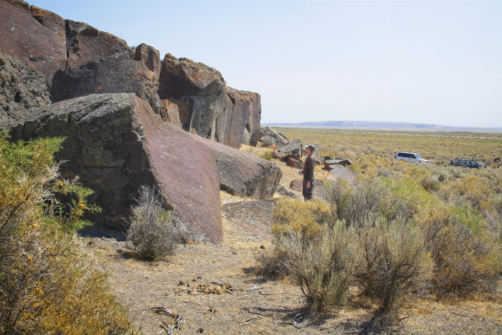
We end up at a spot that looks like it would have been a pretty nice camp for a slightly bigger, higher river. Perhaps the level area where we parked would have been a nice broad beach.


Nearby, a mound of earth features large river polished rocks. Some of these large boulders feature expansive flatish surfaces.


In some cases, it is possible to identify pecked markings - markings formed by the removal of the darker desert patina from the rock’s surface, leaving the lighter substrate to stand out as an intentional design (There may be a pecked oval shape in the center of the rock above).


Elsewhere, where the desert patina does not provide enough contrast, or the artist intended to make a more emphatic point, the pecked lines have been invested with more time and effort until they have become engraved.


I’ve broached the topic of rock art before: https://thenarrativeimage.blogspot.com/2013/11/a-mystery-wrapped-in-enigma-squeezed.html 


…so without going on too much of a tangent, I’ll just say the mystery of it is perpetually tantalizing to me. It’s like finding a message in a bottle…but in a language nobody speaks anymore. How important is the message? Was it sent by someone facing death on a sinking ship? Did seven stranded castaways try to reveal the location of their island? Or is it just advertisements for some shady shaman’s latest herbal remedy or a pubescent youth’s love proclamation for his parallel ‘Tanya’?


Anthropomorphic figures seem to lend themselves to narratives, but it is hard to get beyond pure speculation. I want to know why someone felt it was worth their time to tap a stick figure into a rock next to the river. I try to imagine what the landscape looked like when the drawing was created. I wonder about the art’s placement on the rock. Is the figure obvious, like a sign? Or is the viewer required to climb to a more precarious viewpoint?


Then, while struggling to identify the patterns and the symbols, one must also guard against the tendency to see patterns where they don’t really exist. Am I looking at a meticulously rendered grid pattern, or is this just the way a crystalline basalt weathers over a thousand years?


I find the urge to interpret irresistible.


While this image is visible from the ground, I find I can get a more encompassing shot of it by climbing on top of the rock it’s on and standing. I don’t see it as an animal or humanoid. But maybe it depicts a road - a path - or maybe a map.


(LEFT: Rock-art. RIGHT: Google Earth map)

Just for fun, I check out the landscape as depicted in Google Earth and compare it to the rock-art carving.


Other rocks perhaps carry tally-marks - the counting of specific events, or visits?


Some of the rocks seem to show evidence that a substantially larger river carved and shaped this landscape.


Here, a large boulder appears to have been carved into a big bowl. One explanation for this structure is that it is a pothole - a circular impression in the rock caused by turbulent swirling water that utilizes pebbles and sediments to abrade the rock. These often appear in flowing river beds and absolutely gigantic examples can be found up in central Washington in the landscapes carved by ice-age floods.


In fact, there were countless examples of carved out pot-holes on the Umpqua River.
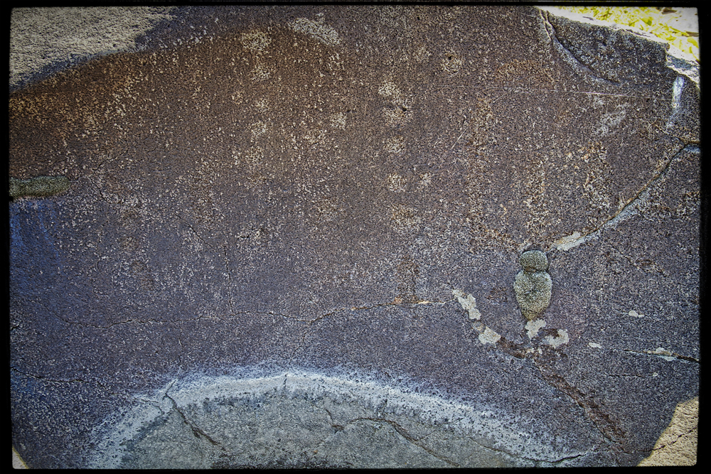


Closer examination reveals that this naturally formed feature has been further refined and decorated. Could this natural indentation have served as a sort of mortar for the processing of grains or medicinal plants?


Given that context, could the markings then be interpreted as a sort of recipe (especially if we assume a much (much) more verdant landscape)?


Of course, now my naive speculations have taken on the ridiculous timbre of pseudo-scientists hawking ancient alien theories. “Could these deep gouges in the rock really be made by mere humans using nothing but sticks and stones, or, is it more likely that this is evidence of aliens with advanced technology?”


(Shout out to Atomic Arts Theater Company for those 5 years when they did Star Trek in the Park - Scene from Journey to Babel.)


The old rock art makes you wonder. Was this area a village? Was it a well known destination? Did it mark a river crossing? Did it mark a boundary between nations? Was it simply an excellent place to fish?


We can at least test that last one out by running a few experiments.


We head back to base camp as the sun approaches its apex.


(Photo Credit: Kip)

At this point, we have been aware of a cluster of house-like buildings up river, but we don’t yet know if they are occupied. This time is as good as any to see if we have neighbors.


 We appear to be alone.


(Photo Credit: Kip)

Back at camp, Rico uses his meat thermometer to give us some idea of how hot it is. Rather ominously, when the breeze blows, the temperature climbs a few degrees more. I begin to appreciate the culture(s) that came up with the idea of siestas.


Soon, we are able to seek out fishing spots next to the river again.


(Photo Credit: Kip)

 Joyful patterns repeat (This is Kip’s stringer)


We are growing short of ice and gasoline. We begin to contemplate tomorrow’s egress from the canyon.


Do you need to catch up with the story? Then follow these links:


PART 1: Hawaii, Owyhee...uh, Boglands (Part One)


PART 2: Hawaii, Owyhee...uh, Böglands (Part Two) 


PART 3: Hawaii, Owyhee...uh, Boglands (Part Three) 


PART 5: Hawaii, Owyhee...uh, Boglands (Part Five) 

Monday, July 31, 2023

Hawaii, Owyhee...uh, Böglands (Part One)


Ruby and Gemma celebrate the end of the world in 2020

In August of 2021, as Summer rounded out the year with its characteristic spurt of heat, Oregon wildfires decided it was finally time to make their bid for infamy and proceeded to scorch the sky by burning 10 times the acreage they burned the previous year. Then, also, U.S. COVID-19 deaths surged past the 600,000 mark (currently 1,127,152) a year and a half after Trump economic advisor Larry Kudlow reassured the public, “We have contained this, I won’t say airtight, but pretty close to airtight. We have done a good job…”


Owhyee Canyonlands in 2021

The Southeast corner of Oregon had long been enticing Kip, Uncle Rico, and me ever since our introduction to Steens Mountain, and though we knew the area was isolated and often desert-like, we also reasoned that triple-digit temperatures somehow seemed more wholesome in an actual desert rather than urban Portland. Shifting winds modulated the atmosphere from opaque to hazy to clear, but never predictably. For the most part, the smoke made even the most epic vistas look something like the dystopian environments depicted in motion pictures like Soylent Green.


Once again we comprised a convoy of two off-road capable vehicles (Rico’s Jeep and Kip’s increasingly capable Montero) and veered off the highway just after taking advantage of an ice-buying opportunity at the Riley Store, which, apart from the post office building across the highway, appears to embody the entirety of the town of Riley.


This region was once covered with Pleistocene pluvial lakes and hosts some of the oldest known inhabited sites in North America. Archaeologists have only recently found artifacts here that suggest humans were in the Riley area 18,000 years ago. With the advent of the Holocene, however, a long drying-out phase began which reduced formerly vast lakes to barren salty playas.


Evidence of a richer past can sometimes be discovered in the flat surfaces of rimrock that overlook long-lost shorelines.


Rock paintings as they appeared              after processing with D-stretch    


Since I was not required to drive, I hadn’t spent as much time previewing the route as I should have. I quickly lost my bearings in landscapes that reiterated a few basic themes about how to become alone and lost.


Eventually, we passed through the Saddle Butte W.S.A. (Wilderness Study Area). It was notable for possessing several lava tubes, one of which we managed to find by assuming a correlation between lava tubes and random rock cairns that dotted the terrain.


Tumbleweed receptacle

Some of the entryways were less amenable to guests than others.


Photo Credit: Kip

Uncle Rico eventually found a path into the underworld.


The cave was cool, but not delightfully cool in the same way that death is restful, but not the way I’d prefer to catch up on sleep. Once we cleared the large boulder-field at the narthex of the cave, the tube traced a serpentine path down a gravitationally defined incline of dried silt accumulated over ages(?) It didn’t take a rocket scientist to notice that, though subtle, the tube was laid out like an elongated funnel. 


I don’t know for sure how far or how long we walked (like fishing stories, spelunking stories lend themselves to exaggeration) until our path terminated in an Uncle Rico shaped hole beyond which Rico didn’t feel the need to probe and Kip and I couldn’t fit.


LEFT: That time lava dripped from the ceiling. CENTER: (Photo Credit: Rico) Mini stalactites? RIGHT: Cave wall with localized mystery sheen.

The walls of the lava tube doubtless tell informative stories to those who can read them. We supposed that we were reviewing a catalog of the different ways basalt can cool from its molten state or the ways chemicals can leech over geologic time. In places, the basalt walls had a curious donut-like icing. Where I was reticent to even touch unknown glazes - my brain harboring references to cautionary horror movies like The Thing, or Stormy Daniel's Bikini Kitchen - Uncle Rico’s scientific curiosity eventually compelled him to lick the wall in a quest for more data points. I don’t think he discovered anything conclusive, but on the bright side, he didn’t drop over dead from some prehistoric pathogen a matter of days later. I am still uncertain whether he should be emulated or not (what if cave walls taste like bacon?).


The question you have to ask yourself in a lava tube (or any cave) is, “How did all those big chunks of rock come to lie on the floor of the cave?” followed by, “Is that concavity in the ceiling a perfect fit for the rock lying below it?” 


Do you ever, when you’re walking down the street, happen upon groups of people being still and quiet, just silently waiting for an earthquake? I haven’t. There’s probably a good reason for that. So to summarize, when deep inside a lava cave, may the odds always be in your favor.


Though hidden in the depths of the Earth, we cannot yet hide from the relentless march of time. Rico reminds us that we must still find a path to the Owyhee River so three intrepid cavemen emerge into the lengthening rays of the sun. We are re-entering a world that teases the apocalypse, but hopefully, we are leaving our misshapen shadows behind on the walls of the cave (Given a little more thought, that could probably be crafted into a fine allegory).


I’m not driving, but I can’t help but notice that our working definition of ‘road’ has become somewhat more elemental. Here, a working road appears to be merely a story told by an unknown predecessor.


The Owyhee River Canyon is, in places, 1000 feet deep and Rico has chosen a particular story about how to get to its bottom. But it turns out the story is out of date and doesn’t account for one deluge or another that erased its physical basis. Given time and resources, we could perhaps create a path, or pick one through the prickly brush, but help is far away and there is no need to go all-in at this point in the trip. 


Deb makes chicken cordon bleu. It's not three species tacos, but it isn't Seven-Eleven roller hot-dogs either. (Photo Credit: Rico)


We retrace our route back to the plateau and set up camp in a bare spot. From this vantage point, half the world is sky and half the world is ground and as the last light from the sun retreats beyond the horizon, we soon discover how dark the nights can be and how radiant the stars.


Would you like to read Part Two? Follow this link:

Hawaii, Owyhee...uh, Böglands (Part Two)

Featured Post

EVOLVING ROADS: Car camping with Kip and Rico (Part One)

I don’t know how it started for sure. Some intrepid band of Homo sapiens maybe walked over a land bridge from Russia or navigated the seas i...

POPULAR POSTS

The Narrative Image NAVIGATION AID