 |
| Ruby and Gemma celebrate the end of the world in 2020 |
In August of 2021, as Summer rounded out the year with its characteristic spurt of heat, Oregon wildfires decided it was finally time to make their bid for infamy and proceeded to scorch the sky by burning 10 times the acreage they burned the previous year. Then, also, U.S. COVID-19 deaths surged past the 600,000 mark (currently 1,127,152) a year and a half after Trump economic advisor Larry Kudlow reassured the public, “We have contained this, I won’t say airtight, but pretty close to airtight. We have done a good job…”
 |
| Owhyee Canyonlands in 2021 |
The Southeast corner of Oregon had long been enticing Kip, Uncle Rico, and me ever since our introduction to Steens Mountain, and though we knew the area was isolated and often desert-like, we also reasoned that triple-digit temperatures somehow seemed more wholesome in an actual desert rather than urban Portland. Shifting winds modulated the atmosphere from opaque to hazy to clear, but never predictably. For the most part, the smoke made even the most epic vistas look something like the dystopian environments depicted in motion pictures like Soylent Green.
Once again we comprised a convoy of two off-road capable vehicles (Rico’s Jeep and Kip’s increasingly capable Montero) and veered off the highway just after taking advantage of an ice-buying opportunity at the Riley Store, which, apart from the post office building across the highway, appears to embody the entirety of the town of Riley.

This region was once covered with Pleistocene pluvial lakes and hosts some of the oldest known inhabited sites in North America. Archaeologists have only recently found artifacts here that suggest humans were in the Riley area 18,000 years ago. With the advent of the Holocene, however, a long drying-out phase began which reduced formerly vast lakes to barren salty playas.
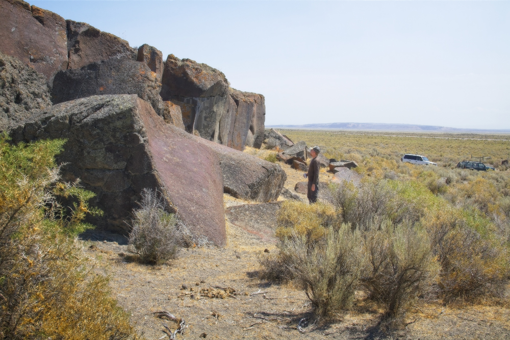
Evidence of a richer past can sometimes be discovered in the flat surfaces of rimrock that overlook long-lost shorelines.
 |
| Rock paintings as they appeared after processing with D-stretch |


Since I was not required to drive, I hadn’t spent as much time previewing the route as I should have. I quickly lost my bearings in landscapes that reiterated a few basic themes about how to become alone and lost.


Eventually, we passed through the Saddle Butte W.S.A. (Wilderness Study Area). It was notable for possessing several lava tubes, one of which we managed to find by assuming a correlation between lava tubes and random rock cairns that dotted the terrain.
 |
| Tumbleweed receptacle |
Some of the entryways were less amenable to guests than others.
 |
| Photo Credit: Kip |
Uncle Rico eventually found a path into the underworld.

The cave was cool, but not delightfully cool in the same way that death is restful, but not the way I’d prefer to catch up on sleep. Once we cleared the large boulder-field at the narthex of the cave, the tube traced a serpentine path down a gravitationally defined incline of dried silt accumulated over ages(?) It didn’t take a rocket scientist to notice that, though subtle, the tube was laid out like an elongated funnel.

I don’t know for sure how far or how long we walked (like fishing stories, spelunking stories lend themselves to exaggeration) until our path terminated in an Uncle Rico shaped hole beyond which Rico didn’t feel the need to probe and Kip and I couldn’t fit.
 |
| LEFT: That time lava dripped from the ceiling. CENTER: (Photo Credit: Rico) Mini stalactites? RIGHT: Cave wall with localized mystery sheen. |
The walls of the lava tube doubtless tell informative stories to those who can read them. We supposed that we were reviewing a catalog of the different ways basalt can cool from its molten state or the ways chemicals can leech over geologic time. In places, the basalt walls had a curious donut-like icing. Where I was reticent to even touch unknown glazes - my brain harboring references to cautionary horror movies like The Thing, or Stormy Daniel's Bikini Kitchen - Uncle Rico’s scientific curiosity eventually compelled him to lick the wall in a quest for more data points. I don’t think he discovered anything conclusive, but on the bright side, he didn’t drop over dead from some prehistoric pathogen a matter of days later. I am still uncertain whether he should be emulated or not (what if cave walls taste like bacon?).

The question you have to ask yourself in a lava tube (or any cave) is, “How did all those big chunks of rock come to lie on the floor of the cave?” followed by, “Is that concavity in the ceiling a perfect fit for the rock lying below it?”
Do you ever, when you’re walking down the street, happen upon groups of people being still and quiet, just silently waiting for an earthquake? I haven’t. There’s probably a good reason for that. So to summarize, when deep inside a lava cave, may the odds always be in your favor.

Though hidden in the depths of the Earth, we cannot yet hide from the relentless march of time. Rico reminds us that we must still find a path to the Owyhee River so three intrepid cavemen emerge into the lengthening rays of the sun. We are re-entering a world that teases the apocalypse, but hopefully, we are leaving our misshapen shadows behind on the walls of the cave (Given a little more thought, that could probably be crafted into a fine allegory).

I’m not driving, but I can’t help but notice that our working definition of ‘road’ has become somewhat more elemental. Here, a working road appears to be merely a story told by an unknown predecessor.

The Owyhee River Canyon is, in places, 1000 feet deep and Rico has chosen a particular story about how to get to its bottom. But it turns out the story is out of date and doesn’t account for one deluge or another that erased its physical basis. Given time and resources, we could perhaps create a path, or pick one through the prickly brush, but help is far away and there is no need to go all-in at this point in the trip.
 |
| Deb makes chicken cordon bleu. It's not three species tacos, but it isn't Seven-Eleven roller hot-dogs either. (Photo Credit: Rico) |
We retrace our route back to the plateau and set up camp in a bare spot. From this vantage point, half the world is sky and half the world is ground and as the last light from the sun retreats beyond the horizon, we soon discover how dark the nights can be and how radiant the stars.

Would you like to read Part Two? Follow this link:


Nice work and it gives me a bit of a kick in the behind to finish up a couple of mostly finished blog posts of my own. Thanks for sharing!
ReplyDelete