Showing posts with label small-mouth Bass. Show all posts

Saturday, August 19, 2023

Hawaii, Owyhee...uh, Böglands (Part Four)

As near as I’ve been able to calculate, the red arrow points to our base of operations on the Owyhee River. This location is at the bottom end of about 48 miles of class II and III rapids - that is, if you happen to be there in the middle of May. If you’re there at the end of August and maybe during a season of drought, traveling by raft is rumored to be problematic.

Sitting in the shade, fishing and drinking beer is nice, but you can’t do it all day. Well, actually, you can do it all day, but we were also cognizant of other points of interest in the canyon.


One such site was archeological in nature, but the people who know of such sites tend to be protective of them - and for good reason.


(LEFT: pictogram peppered with bullet scars. RIGHT: Same image modified with Jon Harmon’s DStretch to better delineate the original art.)

For instance, this antler man that appears near Maupin, Oregon appears to be the victim of fairly intensive target practice.


(TOP: Various carved images - a medallion, a humanoid figure and a sunburst all defaced with spray paint. BOTTOM: The same image modified with Jon Harmon’s DStretch reveals a layer of spray paint that betrays a more modern, angsty origin.)

And these carved petroglyphs (also near Maupin) appear to have been covered in various layers of spray paint.


(Detail of the humanoid carving that appears beneath the ‘N’ in Tanya)
 

(TOP: Original image of pictograms in Picture Gorge. Note graffiti scratched over the top. BOTTOM: The same image modified with Jon Harmon’s DStretch to better reveal the extent of the original pictograms.)

And these Picture Gorge pictograms have likely been damaged by someone wielding a sharp rock as a scraping implement.


Because of the protective reticence to share indigenous rock-art sites, the search for such places becomes something of a puzzle…or a treasure hunt.


Fortunately, Rico is pretty good at teasing the details out of arcane archeological papers and texts…and matching such details to pertinent landmarks.


We end up at a spot that looks like it would have been a pretty nice camp for a slightly bigger, higher river. Perhaps the level area where we parked would have been a nice broad beach.


Nearby, a mound of earth features large river polished rocks. Some of these large boulders feature expansive flatish surfaces.


In some cases, it is possible to identify pecked markings - markings formed by the removal of the darker desert patina from the rock’s surface, leaving the lighter substrate to stand out as an intentional design (There may be a pecked oval shape in the center of the rock above).


Elsewhere, where the desert patina does not provide enough contrast, or the artist intended to make a more emphatic point, the pecked lines have been invested with more time and effort until they have become engraved.


I’ve broached the topic of rock art before: https://thenarrativeimage.blogspot.com/2013/11/a-mystery-wrapped-in-enigma-squeezed.html 


…so without going on too much of a tangent, I’ll just say the mystery of it is perpetually tantalizing to me. It’s like finding a message in a bottle…but in a language nobody speaks anymore. How important is the message? Was it sent by someone facing death on a sinking ship? Did seven stranded castaways try to reveal the location of their island? Or is it just advertisements for some shady shaman’s latest herbal remedy or a pubescent youth’s love proclamation for his parallel ‘Tanya’?


Anthropomorphic figures seem to lend themselves to narratives, but it is hard to get beyond pure speculation. I want to know why someone felt it was worth their time to tap a stick figure into a rock next to the river. I try to imagine what the landscape looked like when the drawing was created. I wonder about the art’s placement on the rock. Is the figure obvious, like a sign? Or is the viewer required to climb to a more precarious viewpoint?


Then, while struggling to identify the patterns and the symbols, one must also guard against the tendency to see patterns where they don’t really exist. Am I looking at a meticulously rendered grid pattern, or is this just the way a crystalline basalt weathers over a thousand years?


I find the urge to interpret irresistible.


While this image is visible from the ground, I find I can get a more encompassing shot of it by climbing on top of the rock it’s on and standing. I don’t see it as an animal or humanoid. But maybe it depicts a road - a path - or maybe a map.


(LEFT: Rock-art. RIGHT: Google Earth map)

Just for fun, I check out the landscape as depicted in Google Earth and compare it to the rock-art carving.


Other rocks perhaps carry tally-marks - the counting of specific events, or visits?


Some of the rocks seem to show evidence that a substantially larger river carved and shaped this landscape.


Here, a large boulder appears to have been carved into a big bowl. One explanation for this structure is that it is a pothole - a circular impression in the rock caused by turbulent swirling water that utilizes pebbles and sediments to abrade the rock. These often appear in flowing river beds and absolutely gigantic examples can be found up in central Washington in the landscapes carved by ice-age floods.


In fact, there were countless examples of carved out pot-holes on the Umpqua River.
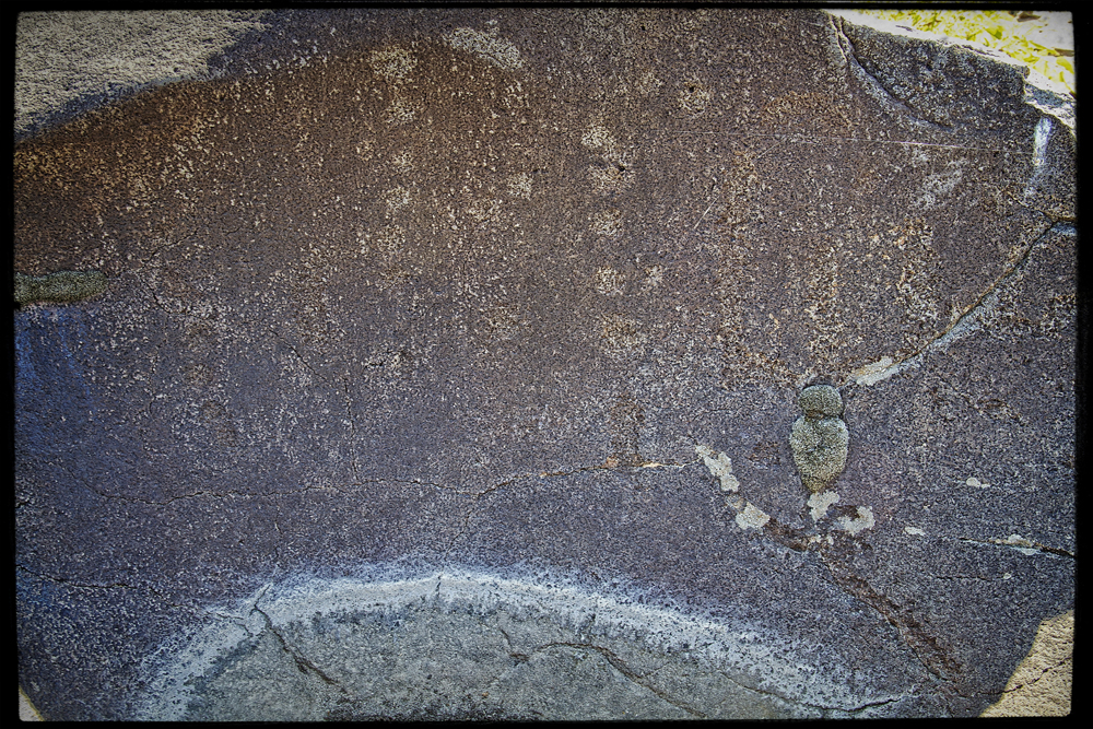


Closer examination reveals that this naturally formed feature has been further refined and decorated. Could this natural indentation have served as a sort of mortar for the processing of grains or medicinal plants?


Given that context, could the markings then be interpreted as a sort of recipe (especially if we assume a much (much) more verdant landscape)?


Of course, now my naive speculations have taken on the ridiculous timbre of pseudo-scientists hawking ancient alien theories. “Could these deep gouges in the rock really be made by mere humans using nothing but sticks and stones, or, is it more likely that this is evidence of aliens with advanced technology?”


(Shout out to Atomic Arts Theater Company for those 5 years when they did Star Trek in the Park - Scene from Journey to Babel.)


The old rock art makes you wonder. Was this area a village? Was it a well known destination? Did it mark a river crossing? Did it mark a boundary between nations? Was it simply an excellent place to fish?


We can at least test that last one out by running a few experiments.


We head back to base camp as the sun approaches its apex.


(Photo Credit: Kip)

At this point, we have been aware of a cluster of house-like buildings up river, but we don’t yet know if they are occupied. This time is as good as any to see if we have neighbors.


 We appear to be alone.


(Photo Credit: Kip)

Back at camp, Rico uses his meat thermometer to give us some idea of how hot it is. Rather ominously, when the breeze blows, the temperature climbs a few degrees more. I begin to appreciate the culture(s) that came up with the idea of siestas.


Soon, we are able to seek out fishing spots next to the river again.


(Photo Credit: Kip)

 Joyful patterns repeat (This is Kip’s stringer)


We are growing short of ice and gasoline. We begin to contemplate tomorrow’s egress from the canyon.


Do you need to catch up with the story? Then follow these links:


PART 1: Hawaii, Owyhee...uh, Boglands (Part One)


PART 2: Hawaii, Owyhee...uh, Böglands (Part Two) 


PART 3: Hawaii, Owyhee...uh, Boglands (Part Three) 


PART 5: Hawaii, Owyhee...uh, Boglands (Part Five) 

Wednesday, August 9, 2023

Hawaii, Owyhee...uh, Böglands (Part Three)

 
The Montero lurches back and forth and sideways. Kip has become adept enough to accurately pick his way between the most aggressive rocks, but it is still a careful balancing act to maintain a speed slow enough to keep us from bouncing our heads off the ceiling, yet fast enough to keep Rico in sight..at least mostly in sight. Then again, it doesn’t pay to follow Rico too closely on account of the curtain of dust tossed up by his tires.

Once again we are approaching the edge of the canyon and once again we will be required to survey our resources and evaluate our prospects. Not having a vehicle, I’m not troubled much with these decisions beyond figuring out which driver is liable to kill me the most and lobbying to ride with the one who won’t. Fortunately, we’ve ridden rapids on wilderness rivers together, negotiated powerful tidal currents together, and together even stood at the edge of Rico’s conspicuously excessive campfires.Maybe all of this has simply fostered a false sense of security, but it might also be interpreted as a history of shared experiences that lead to trust.


Somewhere down there is our campsite. At this point, I feel it is important to add that this picture could have, besides expressing the drama of at least two adventurers facing their unknown futures, easily also been a marvelous advertisement for Pabst Blue Ribbon Beer (Want to sponsor us? Leave a note in the comments). We all drink it, and some of us drink it exclusively (We’re talking about you, water!). Just what do you think Rico and Kip have in their hands right now?


Imagine product placement like this…


Or this (see what we’ve done there? It says Drive Slowly and Enjoy BeEr!).


The path before us surrenders more and more of its area to encroaching vegetation and the grade becomes more pronounced.


But finally we begin to catch glimpses of the Owyhee River.


In a parched land, the shimmering, pulsing artery of blue and green is unmistakable, bringing the possibility of life to this vast landscape.


As the path grows narrower and as it begins to trace switchbacks into the hills in its effort to dip to the valley floor, we become aware that in places, we may find it difficult or impossible to turn around - that is, once we begin our decent, we may be forced to proceed forward unless, as a driver, you can tackle complicated off-road bits going backwards. So perched on the edge of Yoda’s proverbial, “...do or do not.” Rico elects to reconnoiter the route ahead on foot.


To me, the route looks kind of crazy. It straddles the pointy edge of a ridge that makes it look like Kip and Rico will be driving on the cutting edge of the curved blade of a scimitar.

And this I suppose, is the reason we go on these camping trips. Up until this point, you could say we’ve been on vacation. We’ve been on a guided tour. We’ve visited spots along the way, like you do on the way to Disneyland. But now, just maybe, there’s a chance that this can all turn into an adventure. We don’t know exactly where we will camp. We don’t know exactly how or if we’ll get there. We’ve found a place to step into the unknown - a place where we can take calculated risks and the results will depend on the quality of our decisions and our skills.


Now, instead of the mediators our culture has devised to serve as a safety net, we will be dealing more directly with the Earth. Granted, we aren’t exactly adrenaline junkies, but I feel it is correct to say that finding that primal connection - fitting more closely into the Eco-system - slipping back into the food chain - somehow it feeds latent appetites.

Our day-to-day media-rich environment is saturated with memes that implore us to “Boldly go where no one has gone before” or “...take the road less traveled”, or “Don’t follow any path at all…but make a trail”. Cinema, literature, music, they all have substantial road-trip genres. Even our earliest stories, our scriptures and our myths tell of adventurers and quests and God imploring patriarchs to step into unknown futures.


“...Mellow is the man who knows what he’s been missing

Many, many men can’t see the open road…”

- Led Zeppelin 


If all goes well, we assume we’ll soon be passing by that lone shrub down below.


It seems the Owyhee has meandered back and forth across the wide valley floor for a very long time. The place it has settled in for now is far away from the picturesque canyon walls. The river wears a delicate necklace of grasses and shrubs and opportunistic trees. We find a small stand of trees with healthy canopies and set up camp.


Up river, the road terminates in an abandoned ranch. The canyon stretches around a bend and on out of sight.


Tall grasses grow along the river and hide its banks in shade…


Photo Credit: Rico
 

…and Uncle Rico quickly sets about filling up his stringer.


Photo Credit: Kip
 

For a change, I try to remember how to clean fish without asking Rico again.


Kip and Rico have already begun setting up the kitchen.


Rico deep fries the batter-dipped small-mouth bass.


Kip acts as bartender.


Fish Taco (One species, two if you count avocado as a species)


Now that we are in the canyon, the temperature at night is much warmer. Even so, the increase in insects spurs Kip to break out his tent.


Deb catches the four Galilean Moons careening around Jupiter

...to be continued...

PART 4: Hawaii, Owyhee...uh, Boglands (Part Four) 

Have you missed any previous installments?

PART 1: Hawaii, Owyhee...uh, Boglands (Part One)


PART 2: Hawaii, Owyhee...uh, Böglands (Part Two) 

Featured Post

EVOLVING ROADS: Car camping with Kip and Rico (Part One)

I don’t know how it started for sure. Some intrepid band of Homo sapiens maybe walked over a land bridge from Russia or navigated the seas i...

POPULAR POSTS

The Narrative Image NAVIGATION AID