Showing posts with label invasive species. Show all posts

Thursday, August 16, 2018

RED SUN RISES, WILLAMETTE FALLS

They say Native Americans carved petroglyphs at the base of Willamette Falls, an ancient fishing site. I’ve paddled up to the falls a couple of times to find the old markings, but always seem to miss them. The massive horseshoe-shaped falls are over a quarter mile wide and are blended in with concrete and steel industrial structures that make its natural configuration something of a puzzle.

I figured a fresh set of eyes would improve my chances of finding the petroglyphs, so I invited Karen, who had previously expressed an interest in learning to kayak. Karen and I are part of the same extended church family, but more like cousins who almost never visit each other. In the past, she has tried to kill me with a heavy piƱata stick and also a spring roll (the spring roll wasn't really her fault). Having Karen along makes even the most pedestrian outing more like a life and death adventure — at least for me.


Smoke, presumably from California’s wildfires, interfered with the dawn and colored the landscape and everything in it with a hellish red tinge.


We launched from behind an R.V. park, leaving our vehicles on the beach.


clicking on the photo should result in the display of a larger image, the same one, just larger
The falls are visible from high atop the bluffs of Oregon City or the I-205 overlook, but to get to the base of the falls requires a boat (or bolt cutters) (or a particular set of skills).


Nope. No petroglyphs here.


I try to imagine what the falls looked like before we bent them to our will.


Noting the artificial structures rimming the top of the falls, I wonder if this is really a waterfall or a dam. 


The height of the falls is listed at 40 feet. I don’t think that includes the concrete structures above the falls. Scampering among the boulders at the base of the falls, it is unsettling to remember what this place looks like when the river is near flood stage.


The concrete structures inundated in the tumult above are the same concrete structures at the top of the falls pictured in the previous picture. This is the view from the Oregon City bluffs during a high-water event in January of 2012.
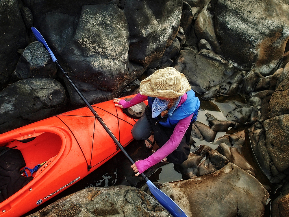


Karen secures her kayak, spontaneously fitting available equipment to nature’s proffered landscape. 


We look everywhere, but can’t seem to find the elusive petroglyphs.


So is it just me, or, painted on the spider’s abdomen, is there a picture of Osama Bin Laden sitting in a chair, facing the viewer with legs all akimbo?


Big industrial parts, complexly designed, intended to spin, possibly refractory,  and abrasive in nature.


I thought it was just a pretty flower — like maybe a morning glory, but Karen called it bindweed, an invasive monster that chokes out native species. Then I was able to trace its red tendrils spreading through the grass and shrubs like a cargo net.


The back end of a turbine system?


Purple loosestrife, another invasive species, brings my invasive species count up to two. Then I glance at the rusting industrial facilities perched on the river banks and add a third species.


The Oregon City Bridge


At the end of the adventure, sharing a picnic lunch with yellow-jackets, I thought this one’s face looked familiar. 


Zanti misfit courtesy of The Outer Limits.

Tuesday, May 20, 2008

CHEMEKETAN CANOE-KAYAK EXCURSION @ SMITH & BYBEE LAKES

Sooner or later even my Dad recognized that, come spring, the yard needed some attention and the hedge some trimming. After the inexpert botanical butchering was complete and a chaos of slaughtered plants lie piled on the sidewalk, it would fall to me and my brother to load all the debris into the bed of the old orange and white Studebaker.

Then Dad would fire up the relatively newer Ford LTD station wagon (featuring less than convincing wood panel decals) and butt it against the front of the Studebaker so the jumper cables would reach. Somehow, between the three of us, all the buttons and pedals of both vehicles would finally be manipulated in concert to resuscitate the old pickup and bring it roaring to life amidst oily smoke and un-muffled mechanical despair. The fact that the gas gauge had always been broken only seemed to add a certain element of excitement to the adventure as Dad and his two little co-pilots would begin what could very well be a one way trip out to the old St. John’s Landfill where all the rest of Portland would come to dump their garbage for another decade.

Now that big pile of garbage still stands menacingly beside Smith and Bybee Lakes, its feet carelessly dangling in the water and its immense crown thinly disguised under an artificial looking veneer of real grass.

This location is where the canoe and kayak division of the Chemeketans arrived to explore what are now considered to be the largest seasonal wetlands within an American city. Chemeketa is an Indian way of saying ‘meeting place’ and was once used to describe that area of land now known as Salem. It probably isn’t a coincidence that the Chemeketans are an organization out of Salem that likes to gather together to partake in outdoor activities.

The Chemekatans I have met so far have been extremely friendly and were willing to let me tag along on what was billed as an easy and educational paddling experience. Their group is sprinkled liberally with various experts in scientific topics having to do with botany and uh…accounting, and other outdoorsy related studies. If they don’t happen to have a resident expert on the topic at hand, they often go to the trouble of befriending one.

One of the things I learned is that, as people alter a landscape, say by putting a giant landfill in it for instance or by adding little dams here and there, there are often unanticipated results. Smith and Bybee Lakes are the victims of many such tinkerings. I won’t go into all the details, but I will say that our attitude towards landscapes once considered to be mosquito ridden worthless swamps has evolved as we’ve come to understand the roles such wetlands play in purifying and straining waste from the environment and helping to mitigate flooding. Maybe think of wetlands as if they were a giant liver. Simply artificially altering the level of water in the lakes has given several invasive species of plants opportunities to proliferate.


Parrot Feather, evidently one of the invaders, originally hails from the Amazon River. If you try to kill this plant by hacking at it with a machete, all the little pieces can take root and grow, just like that broom Mickey Mouse tried to destroy in the Sorcerer’s Apprentice.


Several electricity transmission lines march through the middle of Bybee Lake.


The inter-lake trail includes two viewing platforms. This one, facing west on Bybee Lake seems best designed for bird-watching.


The water control device at the intersection of Smith and Bybee Lakes proved to be a frustrating obstacle to really large carp anxious to enter the lakes.


Due to sewer overflows and accumulating PCBs, carp are about the only things willing to swim in Smith and Bybee Lakes…


… oh, and Chemeketans.


Inflated water levels caused by floods or by well intended dams have had an impact on the livelihood of some trees. Over the years I’ve witnessed the gradual disintegration of this old fellow.


High waters subsequent to flooding in 1996 resulted in optimal conditions for a beaver population explosion. Now that Metro is endeavoring to maintain the Lakes as seasonal wetlands, there doesn’t seem to be as many beavers. Still, exploring the ‘fingers’ of the lakes reveals several beaver architectural artifacts, some of which show signs of continuing beaver activity.


Here is how a beaver dam looks today.


Here is how the same dam looked back in 2003.


This natural dam and its reservoir have turned out to be the staging ground for another very successful invader…the yellow flag Iris.


So much vegetable matter grows in the rich mud and sediments trapped by this dam, that it is hard to recognize that it is a dam and not some geographical feature. Water trickles over the dam at a low spot revealing its wooden stick core.


In 2003 it was much easier to tell that this was a beaver dam.


By the middle of summer, there will likely be no water here below the dam save for a beaver dredged canal system that will lead back to the main body of Bybee Lake.


Back out on Bybee Lake with Mt. Hood evident in the background.


We set out for the willow concealed passage to Smith Lake.


We didn’t see any turtles.
For more information about the Chemeketans, visit http://www.chemeketans.org/


Featured Post

EVOLVING ROADS: Car camping with Kip and Rico (Part One)

I don’t know how it started for sure. Some intrepid band of Homo sapiens maybe walked over a land bridge from Russia or navigated the seas i...

POPULAR POSTS

The Narrative Image NAVIGATION AID