Sunday, June 12, 2011

TOURIST for a DAY: Portland and Environs


Mr. ‘T’ travels the world. Armed with a sophisticated, lightweight point and shoot, he documents his travels in the tradition of the best travel photographers. By that I mean, when you look at Mr. ‘T’s travel photos, they provoke a profound sense of wanderlust.

Sometimes it makes me jealous. Why am I not disciplined enough to earmark money for travel? Why don’t I go to more beautiful, exotic places?  But then Mr. ‘T’ mused, “Someday I’d like to photograph Portland a bit like I was a tourist.”


That’s when I was reminded that I actually live in a beautiful, exotic place, and the only reason I don’t notice is because I see it every day. So we agreed to meet after work and try to view our city as if we were visitors.


This is what the south portion of downtown Portland looks like from a vantage point high in Big Pink, the U.S. Bancorp tower. A similar view can be attained by visiting Portland City Grill on the 30th floor. I know this sounds stupid, but for the first time, as I looked at our city pushed to the edge of the river by the West Hills, I think I really began to understand the term, Willamette Valley. From a vantage point looking north, we could track the progress of rain clouds as they filed in from the west, and watched one briefly as it paused at the confluence of the Willamette and Columbia before heading on up the gorge.


So you’d think that a city called Portland would be a land of many ports, but while we certainly have a Port of Portland that entertains ocean going vessels, we’re really named after Portland, Maine. And if a coin flip between the founding fathers of ‘Portland’ had gone the other way, we’d be called Boston.


Pioneer Courthouse square – Portland’s Living Room.


There’s a bronze sculpture (public art) of a man carrying an umbrella and hailing a taxi in Portland’s living room. Since the man with the umbrella is as still as a statue, this poorly (puzzlingly?) placed grape is actually relatively safe. On this day, I find the wing-tips the most pleasing part of the sculpture. Having practiced the process of casting bronze, I briefly consider how I would have achieved this degree of realism and reminisce about my teacher’s cast naked chicken.


One of a pair of guardian lions perches before the gate to Portland’s version of Chinatown.


Powell’s Books is a really big non-virtual bookstore. There are actually books inside that you can pick up and read. Outside is a sculpture that looks like it sprang from the mind of a troubled Dr. Seuss.


This fountain was dedicated to the memory of Stephen Skidmore in 1888 and Henry Weinhard offered to make it flow with free beer (probably for just that first day) but the city incomprehensibly declined.


Reflection of Big Pink in typical Portland puddle.


I didn’t know I needed bacon topped maple bars until a colleague brought some to work. The downtown Voodoo Doughnut location is currently closed for remodeling, but it looks like this new sign is ready to go. The last time I tried to buy a doughnut here, I had to run a gauntlet of homeless people who determined, perhaps rightly, that people who shop for decadent doughnuts must have discretionary disposable income. Either that or homeless people like voodoo doughnuts too.


Back at the beginning of 2008, Oregon was considered one of the most ‘unchurched’ states in America with 24 percent of us claiming no religious identification. This makes Oregon a ripe destination for missionaries. Some religious people might now be encouraged to discover that Oregon no longer leads the nation in this regard, but I don’t think it’s because of the efforts of evangelicals, rather, it’s just that Vermont jumped up to 34%.


It always looked to me like Portlandia should be throwing dice.


This sculpture is officially called The Quest.
But the unofficial names seem more accurate:
"Three Groins in a Fountain" (though there are two more figures on the other side)
"The Grope"
"The Quest for the Breast"
"Family Night at the YMCA"


I looked at this building and saw a building. Mr. “T” looked at this and noted Escher like qualities. So I took a second look and tried to transcend my slavish devotion to narrative and find a pleasing texture/pattern/design…


…and tried again at the Ira Keller Forecourt Fountain…


…but backslid into a narrative about catharsis by the time I encountered the Thompson Elk statue and fountain.


An iconic Benson Bubbler: Free flowing Bull Run water throughout the downtown area.


Speaking of Bull Run water, here is one of the Mt. Tabor open reservoirs that have so far not had any positive Cryptosporidium tests.


Mt. Tabor isn’t actually downtown, but it does have a nice park built on top of it even though it is an extinct (hopefully) volcano. Of course, we thought Mt. St. Helens was kind of extinct too.


Sometimes you can get pretty nice views of Portland from the top of Mt. Tabor. But honestly, I can’t say it’s a big tourist destination.


Rocky Butte - same deal as Mt. Tabor. A small shield volcano - but this one is situated closer to the Columbia and provides views of the airport, interstate 205 disappearing into Washington, and interstate 84 pointing east toward the Columbia Gorge.


The Vista House. An Iconic stop on the old scenic highway.


There are a lot of scenic waterfalls and hiking trails in the Columbia Gorge and it has proven to be very popular with tourists. Many of these features appear on The Narrative Image’s Hike Directory Page (see the tabs at the top of the page) 


But it is also interesting to stop and tour Bonneville Dam to see how we continue to search for the balance between satisfying our need for energy with the obvious need to preserve the very resource we are plundering.


There was evening, and there was morning – another day?

Monday, May 30, 2011

ABIQUA FALLS


The clear-cut hills try to hide their nakedness under wispy cloud covers.


By the grace of the Mt. Angel Abbey, I descend toward the promise of earthly treasure.


- Unique mud slide feature -


Thunder and mist emanate from around the corner… 


First sight. 


Pictures don’t express. 


...like leaving paradise…


Wednesday, May 11, 2011

The Sound of One Hand Clapping: Loring Site 15

(Note: clicking on images should display a larger version)

Graffiti.
Sometimes it’s just a signature – a tag.
Sometimes it’s a message.
And sometimes, it’s art.


Graffiti on a train

Sad thing is…I can’t tell the difference…at least not always. 


Why do we post symbols in public places?


What does a bird mean?


Without proper cultural context…


...can we ever know the original intent of the symbol maker?


I stumbled upon my first pictograph on a kayak/camping trip in 2008.
It’s amazing that these painted images persist.

Is it a message?
An advertisement?
An icon?
...a warning?

Since then I’ve read some Oregon Archeological Society publications (primarily by Keyser) and learned of vision quests, shamans, ghost cults and power drawings. Plus, on the historical context side of the story, I’ve learned that these kinds of painted rock images are the product of a once dominant society that was being decimated by disease and European pioneers.


J. Malcolm and Louise Loring surveyed petroglyph and pictograph sites over the course of decades and documented their research in a two volume monograph called Pictographs and Petroglyphs of the Oregon Country. The Lorings painstakingly drew the images from over three hundred sites and also included cryptic descriptions (well, at least cryptic to me) of their locations.


Last year I went looking for Site 15.


The red arrow shows J.S. scanning the cliffs for pictographs/petroglyphs.


Out in the field, you start asking yourself, “If I was an Indian, where would I paint a picture?”

Then you start asking, “Why would I paint a picture?”

And then when you see where some of the pictures are painted, you start asking, “How?”


While I did find inconclusive scratched images…


…I didn’t find any evidence for Site 15.


…and I didn’t really feel shortchanged.


A couple weeks ago, an internet acquaintance (S.E.) sent me a photo he discovered while out in his kayak. It matched one of the Loring drawings for site 15.


Game on.


There’s a lot of beauty amongst towering basalt cliffs and canyons.


There are peaceful shelters… 


Clefts in the rock…protection from high winds, driving rain and desert sun.


From a precarious perch – a bird’s eye view of the vast Columbia River gorge.


Surreal landscapes featuring rows of unlikely columns.

How did this environment influence the artists?

How different is this dam infested river from the once-upon-a-time wild river that descended through the gorge in thundering cascades?


My search took me into terrain where it appears…


…others have not been so lucky.


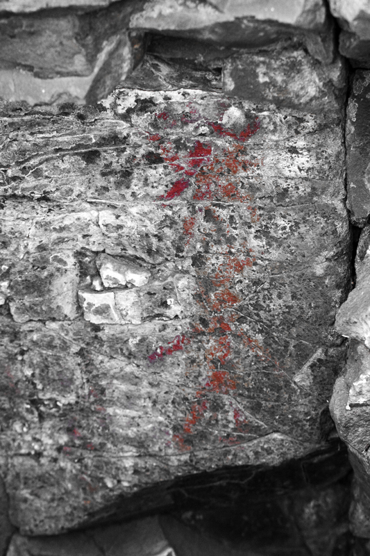
Finally, the tell-tale smudge of red.


Many of the paintings seem worse for wear when compared to the Loring drawings…to the degree that my identifications are not always certain.


By now I feel like an idiot. The same symbols repeated over and over again, and I keep going, “What does it mean? I don’t get it. What does it mean?”


Meanwhile, local inhabitants express, by their actions, a desire to enter into a parasitical relationship.


Mt. Hood broods on the horizon.

Featured Post

EVOLVING ROADS: Car camping with Kip and Rico (Part One)

I don’t know how it started for sure. Some intrepid band of Homo sapiens maybe walked over a land bridge from Russia or navigated the seas i...

POPULAR POSTS

The Narrative Image NAVIGATION AID