Monday, October 22, 2007

Kelly Point Park, Smith & Bybee Lakes and Oaks Bottom Wildlife Refuge


Mt. St. Helens from Kelly Point Park


Gentle wavelets disagreeing – at the bank of the Willamette River


A Ship taking on grain as night falls.


Rhymed couplets


Portland pulls on its winter blanket


The sky reminded me of these ripples. I guess that’s why they call it a jet ‘stream’.


Smith and Bybee Lakes is just down the road to the east of Kelly Point Park – about 5 minutes. By means of a water control device, Metro takes pains to mimic nature’s definition of seasonal wetlands. The acreage here has not yet filled up with winter rain and deer take advantage of the lush grasses and plants that spring forth from the rich sediments exposed to the sky.


The trees here seem to lag behind their higher altitude brethren when it comes to changing color.


Funeral bier at Oaks bottom Wildlife Refuge


Why do these things have hair?


I receive an invitation as I approach the Oaks Amusement Park.


Sunday, October 14, 2007

OPAL CREEK TRAIL to CEDAR FLATS


It’s a paradox. Bars and fences and various gates are clearly intended to keep people out. So why is it that they tend to look like invitations? They scream, “Hey! There’s extremely interesting valuable stuff in here!”

I glanced over to the Monkey-cam and shrugged, “Might as well check it and see if it’s really locked.” But it turned out it was really locked.


Just around the corner was an abandoned work shed with one of the most intimidating danger signs I’ve ever read.
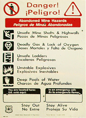


“This,” I said, turning toward the Monkey-cam, “looks like a job for the Monkey-cam.”

The Monkey-cam studied my face. I could almost hear the little wheels spinning in his head. He looked at the mine shaft again, looked at the danger-sign graphics, and reluctantly reached into his pack for his crash helmet while doing a nervous little potty dance.

Trembling, the Monkey-cam cinched his chin strap. I couldn’t keep a straight face any longer. “I’m joking, you little dork.” I finally confessed.

We went back to peer through the gate into the depths of the mine shaft, but it was dark and we couldn’t see anything.


I reached into my pack for the safety matches and pretended like I was going to strike one on the side of the box to light it. The Monkey-cam took one look at the matches, dropped his back-pack and was one-hundred yards away within six seconds. That’s when I realized he could read.


(click on image to view larger version)


We spent some time exploring the falls below the rickety old work shed.


We found gold


And emerald


And molten water


The trees donated their gold to the local eco-system.
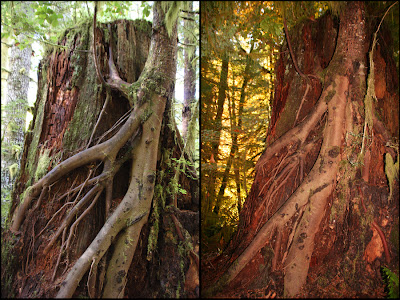


Sometimes, when an old friend dies, it is hard to let go.

(Note: Usually, my camera is way smarter than I am and it does an O.K. job of exposing pictures, but after reviewing the picture on the left, I was disappointed to see that in order to properly expose the tree, the background got washed out. I thought maybe if I used the flash as fill, I might be able to capture the light in the background filtering through the forest canopy from the rising sun, but I’m not sure I like how flesh-like the tree turned out.)
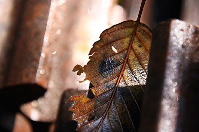


Along the road, there is deserted mining machinery - wheels, gears, chains, boilers, and sections of rail – cast off and forgotten like autumn leaves.


By the time I got to Sawmill falls (at least I think it was Sawmill falls), the sun was finally rising above the hills and poking fingers of light into the valley.


I liked how the sunbeams highlighted sections of the falls.


The lazy October sun haphazardly set about drying the ancient forest here and there.


Under the sun’s gaze, dew-laden webs dried and returned to functional invisibility.


The understory illustrated.


The under - understory


The falls above Opal Pool


There’s that rock again.


A scene from Opal Pool


I set up the tripod and took a long exposure looking down into the water of Opal Pool. The orange-brown streak at the water’s surface in front of the red rock is the path of a leaf headed downstream (admittedly, it's hard to see).


Looking downstream from Opal Pool


The business part of this bridge is a single tree with the ‘top’ side flattened a little. The fuzzy effect isn’t due to a Photoshop filter. Evidently, if I hold my camera while I’m hiking in cool weather, I create a temperature differential that causes some condensation problems with the UV filter on the front of the lens.


On the path to Cedar Flats, I encountered an area rich with understory and I spent some time trying to catch an image that would depict the delicate calligraphy-like structure of the sheltered yellow canopy of deciduous leaves. It was hard because there isn’t anything obvious to focus on. Even worse, in the dim light of the ancient forest, the depth of field is so narrow that almost nothing is in focus anyway.


Frustrated I turned away only to find this giant cedar watching. To my lasting shame, I didn’t manage to get this picture in focus either.


Ultimately, underneath the pines and cedars, underneath the deciduous understory, underneath the bushes and ferns, lies the forest floor, covered in a rich shag layer of moss.


Cedar Flats


Tuesday, October 9, 2007

Kayaks on the Sandy River – A True Story

Prologue:


paper boat
cast adrift on the current
sent on an indeterminate voyage
bound to get soggy
destined to sink
fun in the journey
(for the creator?)


silver fry
cast adrift on the current
sent to the ocean
bound to return
destined to spawn (and die)

(Fun in the journey?)


the River
the Current
carries us along

Maybe we understand the river is a metaphor.
Maybe we learn to read the currents and risk the rapids in order to live out the story, to wager our lives and prove we can win…sometimes.

Maybe.


The Narrative:


Well, I don’t know about all that philosophical crap, but my brother Fred, the Monkey-cam and I decided to try kayaks on the Sandy River. We started at the far end of Oxbow Park with the intention to make it down to Lewis and Clark State Park.

None of us had ever taken kayaks down a river before, not even the Monkey-cam, and I don’t think I’d taken my canoe down since before the floods in November – the floods that significantly rearranged the landscapes of the Northwest’s strato-volcanoes.

As I’ve hiked various trails around the three ‘guardian’ peaks (Adams, Hood & St. Helens) I’ve come to realize that mountains are far from static environments. I think that in terms of geologic timeframes, a volcano is like those pyramid shaped stacks of oranges at the grocery store which can collapse quickly and completely if you take out an orange from the bottom row.

The Sandy River is a child of Mt. Hood.
Evidence of its dynamic potential was everywhere evident.

I picked this particular section of the Sandy River because it was supposed to be lacking in significant rapids – the kind that demand the technical kayaking excellence that none of us possessed. But an ominous roar from an unexpected location ahead suggested that we should pull ashore and scout downriver by foot – just to be safe.


What we saw was an incredible uncharted waterfall formed by accelerated erosion. I had little doubt that the unconsolidated debris carried by November’s record rainfall was somehow responsible for this new river feature. I’m a little hazy on the location. It was somewhere between Oxbow Park and Dabney State Park, but, as big as it was, it seemed extremely unstable, and for all I know, it may have been worn down since then. As I studied it, it didn’t escape my attention that it looked remarkably similar to Falls Creek falls, though more like a mirror image.


I had seen mountain climbers on T.V. outline their assaults on Mt. Everest, so, in a similar fashion, I drew up a preliminary plan for our route down the falls. I knew our borrowed Pungos, with their ‘V’ shaped hulls were not ideal for maneuvering in rapids like these, but all of us had drunk enough of Fred’s homebrewed beer to believe that it really wouldn’t be that hard.


Never-the-less, Fred and I determined that the Monkey-cam should go first – just in case.


The Monkey-cam courageously followed my proposed route to the edge of the precipice (bless his heart) with disastrous results. Fortunately, he was dexterous enough to leap form the Pungo to some nearby branches. (I’ve decided his probation period is over.) You can see the Monkey-cam’s wrecked Pungo submerged in the punchbowl at the base of the falls (a punchbowl remarkably similar to the one I’ve seen on the Eagle Creek Trail.).


Fred was up next.

Having seen what befell the Monkey-cam, and keenly aware that he would be unable to leap from his kayak, Fred chose to use ‘the Force’ like Luke Skywalker in the first Star Wars movie. At least that’s the reason he said his eyes were closed.


Halfway down the stretch of rough water, Fred, like a bareback bronco rider, demonstrates his excellent, evidently instinctual balance and form.


All I had to do was follow Fred’s path.


It really didn’t help much to paddle in the midst of the cascading torrent, but I noticed that once you got going fast enough, you could use your paddle to fly much like flying squirrels use flaps of underarm skin. In this manner, I was able to avoid the hidden rocks (rocks that are remarkably similar to the rocks at the base of Latourell Falls) cloaked by the dynamic white robe of water approaching terminal velocity.


I can’t speak for Fred, but in my own case I believe it was my super buoyant love-handles that minimized the time I spent underwater (for some reason, this scene reminds me of the upper section of Pup Creek Falls.)


We got lucky this time. We triumphed against the river. We demonstrated that we could take our destinies into our own hands…at least for a time. We perpetuated the illusion of free will and self determination.

Mostly, we had fun.

Featured Post

EVOLVING ROADS: Car camping with Kip and Rico (Part One)

I don’t know how it started for sure. Some intrepid band of Homo sapiens maybe walked over a land bridge from Russia or navigated the seas i...

POPULAR POSTS

The Narrative Image NAVIGATION AID