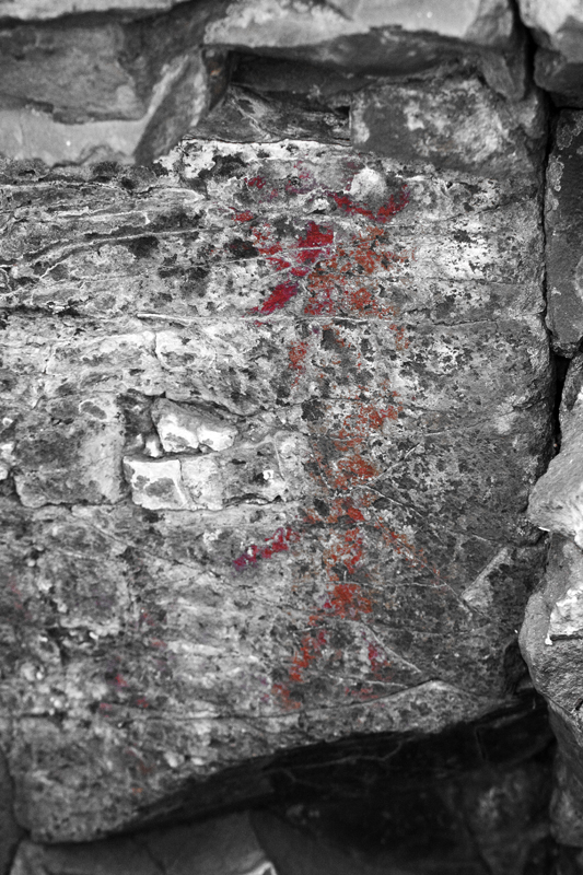
The Sound of One Hand Clapping: Loring Site 15

(Note: clicking on images should display a larger version)

Graffiti.
Sometimes it’s just a signature – a tag.
Sometimes it’s a message.
And sometimes, it’s art.


Graffiti on a train

Sad thing is…I can’t tell the difference…at least not always. 


Why do we post symbols in public places?


What does a bird mean?


Without proper cultural context…


...can we ever know the original intent of the symbol maker?


I stumbled upon my first pictograph on a kayak/camping trip in 2008.
It’s amazing that these painted images persist.

Is it a message?
An advertisement?
An icon?
...a warning?

Since then I’ve read some Oregon Archeological Society publications (primarily by Keyser) and learned of vision quests, shamans, ghost cults and power drawings. Plus, on the historical context side of the story, I’ve learned that these kinds of painted rock images are the product of a once dominant society that was being decimated by disease and European pioneers.


J. Malcolm and Louise Loring surveyed petroglyph and pictograph sites over the course of decades and documented their research in a two volume monograph called Pictographs and Petroglyphs of the Oregon Country. The Lorings painstakingly drew the images from over three hundred sites and also included cryptic descriptions (well, at least cryptic to me) of their locations.


Last year I went looking for Site 15.


The red arrow shows J.S. scanning the cliffs for pictographs/petroglyphs.


Out in the field, you start asking yourself, “If I was an Indian, where would I paint a picture?”

Then you start asking, “Why would I paint a picture?”

And then when you see where some of the pictures are painted, you start asking, “How?”


While I did find inconclusive scratched images…


…I didn’t find any evidence for Site 15.


…and I didn’t really feel shortchanged.


A couple weeks ago, an internet acquaintance (S.E.) sent me a photo he discovered while out in his kayak. It matched one of the Loring drawings for site 15.


Game on.


There’s a lot of beauty amongst towering basalt cliffs and canyons.


There are peaceful shelters… 


Clefts in the rock…protection from high winds, driving rain and desert sun.


From a precarious perch – a bird’s eye view of the vast Columbia River gorge.


Surreal landscapes featuring rows of unlikely columns.

How did this environment influence the artists?

How different is this dam infested river from the once-upon-a-time wild river that descended through the gorge in thundering cascades?


My search took me into terrain where it appears…


…others have not been so lucky.


Finally, the tell-tale smudge of red.


Many of the paintings seem worse for wear when compared to the Loring drawings…to the degree that my identifications are not always certain.


By now I feel like an idiot. The same symbols repeated over and over again, and I keep going, “What does it mean? I don’t get it. What does it mean?”


Meanwhile, local inhabitants express, by their actions, a desire to enter into a parasitical relationship.


Mt. Hood broods on the horizon.

Comments

  1. Pretty fantastic!

    ReplyDelete
  2. This morning I came into work and found similarly perplexing markings on my overhead garage door. I suspect that at least some of the drawings you're showing were made by an ancient mischievous little prick that was thinking "someday someone will see this and ask 'what's that and how the hell did it get way up here?'" I'm just venting I guess. Nice pictures though.

    ReplyDelete

Post a Comment

Popular posts from this blog

Test Paddling the Thresher 140

Wilderness Systems has broadened their sit-on-top offerings this year with the introduction of the Thresher (this includes a 14 and 15.5 foot version). The Thresher seems designed to bridge a gap between overly stable, relatively slow fishing platforms and sleeker more touring-orientated craft, all for the sake of fisher-people who need to cover significant distances to reach their intended fishing locales, whether that's in the middle of a huge bay or out beyond the breakers in the open sea The characteristics that make this boat a good fishing option, should also make it a killer expedition photography platform/beer barge. I knew my test trials wouldn't be complete until I auditioned this state of the art bid for kayak fishing supremacy. The Thresher 140 I've probably been remiss for not highlighting this before, but the reason I've been able to rent and evaluate various sit-on-top kayaks is because of the reasonable and renter friendly policies of the ...

Miller Island Expedition: Columbia River Ghost Cult

My brother Fred sent me a checklist of things he didn’t want to forget for our second attempt at a Miller Island Expedition. Foil pans Steak Beer or whiskey/tequila Bacon Shovel TP Bug spray Homebrew Ghost repellents Scouting Miller Island from the Lewis and Clark Highway (Washington side of river) “Ghost repellents?” I asked. Well, it turns out that Fred had been doing some research and found an old article from American Anthropologist by Wm. Duncan Strong called The Occurrence and Wider Implications of a “Ghost Cult” on the Columbia River Suggested by Carvings in Wood, Bone and Stone. The article, written in 1945, revealed that bone carvings depicting figures with prominent rib cages, a symbol of death, were found in old cremation pits on Miller’s Island. Excerpts from the article: “It can be shown that among these peoples there was an old belief in the impending destruction and renewal of the world, when the dead would return…” “One of the most striking fea...

John Day River: Thirty Mile Creek to Cottonwood Bridge

"Ever since the creation of the world his invisible nature, namely, his eternal power and deity, has been clearly perceived in the things that have been made. So they are without excuse;" -Romans 1:20 "I'm not so sure about that, but whether or not we all make it through these rapids alive, I'm confident the grading criteria will be fair." -  Scott "Get ready to explore your world without boundaries." -  Wilderness Systems Owners Manual Sunrise found us on the outskirts of Wasco, high on the Columbia Plateau, our 3 vehicle convoy speeding through golden fields of wheat on toward Condon and then West to a 7:30 AM meeting with a rancher who would provide us a private launch site to the John Day river and also execute our car shuttle.   Startling verdant fields, free of the vestiges of irrigation, belied narratives of drought that punctuated the news. The fresh born morning, still cool to the senses, felt like the fledgling hours of a...